Nqobile Tshili, Chronicle Reporter
SOUTHERN African countries, including Zimbabwe, are likely to receive above normal rainfall following the prediction of a La Nina season in the 2020/21 rainy season.
In a La Nina climate pattern, the winds above the Pacific Ocean are much stronger than usual, contributing to increased rainfall and the phenomenon occurs once every few years.
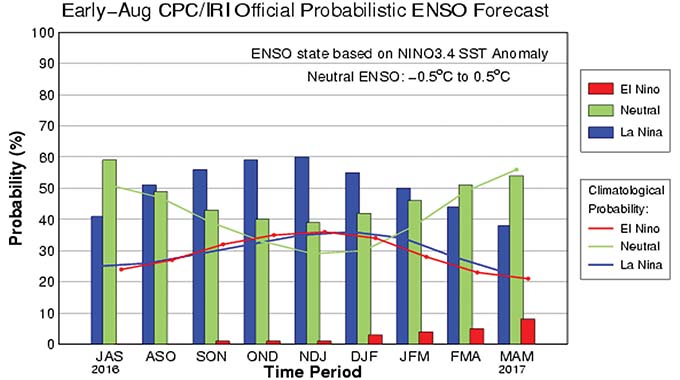
The last time the region experienced a La Nina rainy season was in 2016/2017, the last time Zimbabwe had meaningful rains.
Since then, the country has experienced erratic rains resulting in successive droughts with devastating effects for both humans and livestock.
Bulawayo is experiencing one of the worst water crises and city has had to decommission Lower Ncema, Upper Ncema and Umzingwane dams.

This has left the city three supply dams Inyakuni, Mtshabezi and Insiza dams, forcing the local authority to impose a 144-hour water shedding exercise to conserve the dwindling supplies.
The climate change-induced drought situation has increased the vulnerability of members of the public with at least eight million being food insecure countrywide.
Farmers have been losing their livestock in huge numbers as they run out of pastures while water bodies have been drying up.
Ahead of the 2019/20 rainy season, the United States Columbia University’s Climate Prediction Centre (CPC) and the International Research Institute for Climate and Society, have issued La Nina season alert for Southern Africa for the 2019/2020 rainy season.
The rainy season normally commences at the end of October in Zimbabwe and ends in April.
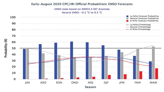
“It is that time of the year when climatologists, globally and sub-regionally, begin to firm up their forecasts for the coming rainy season in Southern Africa. The latest CPC/IRI ENSO probability forecast produced early August indicates that there is a 60 percent chance of La Nina for September-November and 50 percent chance for continuing through December-February. As a result, the CPC/IRI has issued a La Nina alert,” read the weather projections.
“La Nina is generally associated with increased probability of above-average rainfall from November to April for most of Southern Africa. Just to remind you that the last time we had a La Nina event was in 2016/2017.”
The country’s Meteorological Service Department (MSD) said while it has noted the prediction by the international institution, it is working on a localised forecast for Zimbabwe.
MSD head of forecast Mr James Ngoma said the localised forecast will be released soon.
“We are working on our own projections for the season. We were actually looking at a number of systems that affect us including the south west Indian ocean and sea surface temperature including that La Nina that is in the South East of Australia. Currently, we are working on projections for Zimbabwe in particular, we should be out with the seasonal forecast in the next coming days,” said Mr Ngoma.
He said a La Lina season, however, indicates improved rains for the country.
“For the La Nina season, it usually indicates a better season than normal. But that is a broad forecast as it covers the whole Sadc region but we are doing one which is specific for Zimbabwe,” he said.
Mr Ngoma said when an area gets above normal rainfall it would have received more than what it normally gets in an average year.
He said above normal rainfall is calculated using the average rains received within a 30-year period, adding that rainfall predictions are area specific.
“So, in general we know what is normal for Beitbridge is not what is normal for Harare, Bulawayo or Inyanga. So, a specific area has a specific normal. So, when we say an area is going to receive above normal rainfall, we mean you will get more than what you normally get at an average year which we calculate on a 30-year basis. So, it means receiving more rains than the average range of that normal. Each area has a specific range of figures that signify their normal and when we say it’s going to be above that normal; we mean that it is going to be exceed that actual value,” he said. – @nqotshili.
